A newly published article in the Guardian attempts to scaremonger Bostonians by claiming rising seas will inundate large swaths of Boston. Only the very wealthy will be able to pay for expensive measures to keep the sea at bay, the article claims. However, sea level rise is nowhere near the threat the Guardian claims.
Climate zealots have the idea that cities that have withstood rising sea level for centuries will suddenly pack up and leave if threatened by a few inches in the present day. The Guardian does, however, make one valid point: Boston, like many U.S. coastal cities, is mostly built on landfill. For example, Boston’s Logan International Airport was built on a series of sandy islands, and now is one of the busiest airports in the United States. It is normal for landfill to gradually subside over time, and that makes those areas more susceptible to the small amount of naturally occurring sea level rise that has been occurring since the end of the Little Ice Age around 1850.
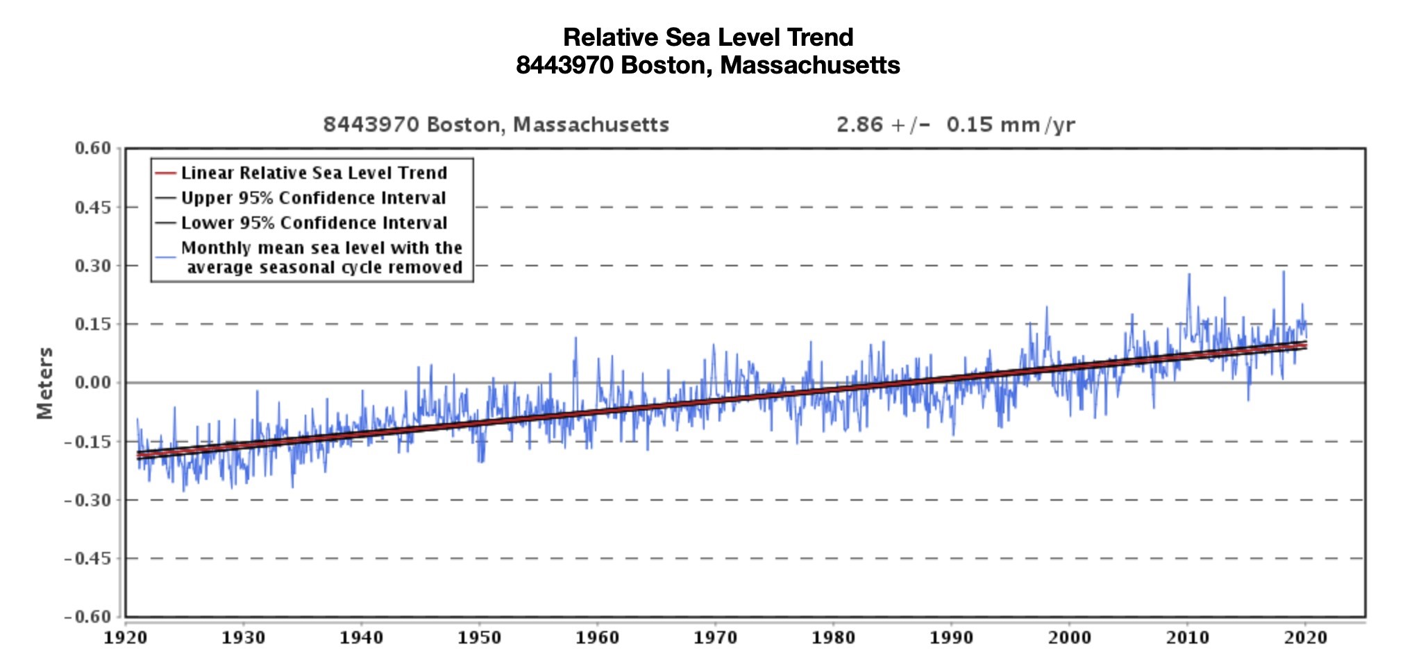
The bottom line is that Boston has been dealing with sea level rise for well over a century, and the city has won. There’s no acceleration in sea level rise. Boston tidal gauge data show sea level is rising at the very same rate it was a century ago.

Figure 1: Tide gauge data from Boston. The relative sea level trend is 2.86 millimeters/year with based on monthly mean sea level data from 1921 to 2019 which is equivalent to a change of 0.94 feet in 100 years. Source: NOAA Tides and Currents
And, if you look at the 2010-2020 decade in the graph, it appears there has been no sea level rise at all in Boston during the past decade.
Similarly, New York City has been mitigating sea level rise far longer than Boston, and none of the overhyped apocalyptic predictions have come true there, either.
The Guardian article also fails to give readers the full story behind the 2014 photo they used of a firefighter wading through a flooded section of Boston, suggesting the flooding was caused entirely by climate change.
Interestingly, the Massachusetts Institute of Technology (MIT) scientifically illustrates a rare event that caused flooding in a section Boston in 2014 that was the cause of the flooding in the photo the Guardian used in 2020. The flooding was the combination of two events; a higher than normal tide driven by a supermoon event, and storm surge pushed onshore by a powerful nor’easter storm, much like hurricanes produce storm surge.
The MIT team writes:
“The result? Normal tides in Boston are between 9 and 10 feet, but this storm brought a little something extra. The city saw the highest water level at 15.16 feet, with storm surge topping 4.88 feet mean higher high water (MHHW). The nor’easter also dropped more than a foot of snow in the Boston area.”
Blaming “climate change” for flooding driven by two coinciding natural events is a fool’s errand. And no, Bostonians, you will not have to run for the hills to escape sea level rise.


