


The Washington Post (WaPo) ran a story recently saying that sea level rise has become unprecedented on the east and southeast coast of the United States. This can be seen in the map in the screen capture above. The story is extremely misleading when not outright false. WaPo fails to explain that the areas it highlights are naturally unstable with their shores waxing and waning regularly. There is no long-term consistent trend of rapidly rising sea levels.
The story THE DROWNING SOUTH – WHERE SEAS ARE RISING AT ALARMING SPEED by Chris Mooney, Brady Dennis, Kevin Crowe and John Muyskens makes some highly questionable claims:
One of the most rapid sea level surges on Earth is besieging the American South, forcing a reckoning for coastal communities across eight U.S. states, a Washington Post analysis has found.
At more than a dozen tide gauges spanning from Texas to North Carolina, sea levels are at least 6 inches higher than they were in 2010 — a change similar to what occurred over the previous five decades.
In the story, WaPo presents this table:
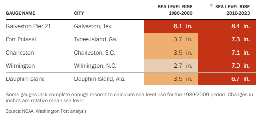
Figure 1 – Table from WaPo
One of the featured places by WaPo is Dauphin Island, Alabama, which is a good example to demonstrate how WaPo has presented misleading and outright false information.

Figure 2. Dauphin Island, Alabama
Dauphin Island is essentially a sand bar, a barrier island indicated by its elongated shape. Barrier islands, by definition are fragile, being affected by many things, according to HowStuffWorks:
- Waves – Waves continually deposit and remove sediments from the ocean side of the island.
- Currents – Longshore currents that are caused by waves hitting the island at an angle can move the sand from one end of the island to another. For example, the offshore currents along the east coast of the United States tend to remove sand from the northern ends of barrier islands and deposit it at the southern ends.
- Tides – The tides move sediments into the salt marshes and eventually fill them in. Thus, the sound sides of barrier islands tend to build up as the ocean sides erode.
- Winds – Winds blow sediments from the beaches to help form dunes and into the marshes, which contributes to their build-up.
- Sea level changes – Rising sea levels tend to push barrier islands toward the mainland.
- Storms – Hurricanes and other storms have the most dramatic effects on barrier islands by creating overwash areas and eroding beaches as well as other portions of barrier islands.
It is misleading that WaPo doesn’t point out how tenuous the existence and stability of places like Dauphin Island are. Here’s what WaPo claims is happening there:
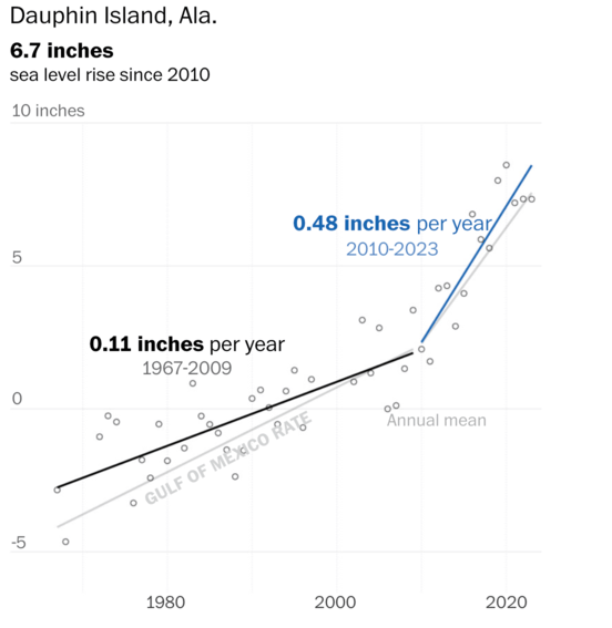
Figure 3. The WaPo’s graph claiming accelerating sea level rise on Dauphin Island.
SOURCE: Washington Post
Note that WaPo claims 6.7 inches of sea level rise since 2010. However, here’s what National Atmospheric and Oceanic Administration (NOAA) data says about the sea level rise on Dauphin Island:
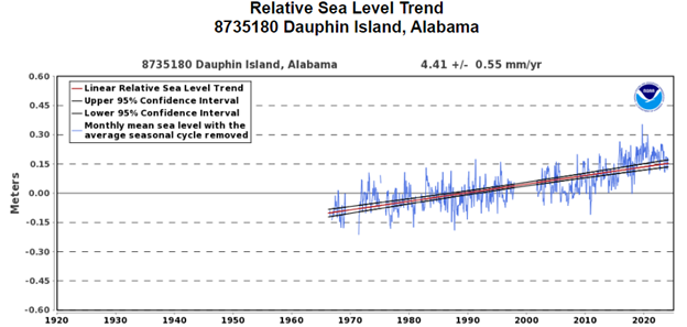
Figure 4. NOAA relative sea level trend, Dauphin Island, Alabama. SOURCE: NOAA
Note that WaPo hasn’t displayed the last part of the data for 2024 in their Figure 3 graph, stopping at 2023. 2024 data shows that Dauphin Island sea level rates are back to historical norms. But, even without that omission, it is easy to show how WaPo has presented a false claim with simple math.
WaPo claims that 6.7 inches of sea level rise since have occurred between 2010 ending in 2023 – fourteen calendar years. If that were true, the NOAA data would support it, but it doesn’t.
NOAA’s actual data from the full dataset says the sea level trend is 4.41 millimeters/year at Dauphin Island and it returned to that level in 2024 after a short increase in trend the years before. From NOAA’s data page on Dauphin Island:
The relative sea level trend is 4.41 millimeters/year with a 95% confidence interval of +/- 0.55 mm/yr based on monthly mean sea level data from 1966 to 2023 which is equivalent to a change of 1.45 feet in 100 years.
Let’s do the math:
4.41 mm/year x 14 years = 61.74 mm
61.74mm = 2.43 inches, not 6.7 inches, just over a third of the amount of sea level rise WaPo claimed for Dauphin Island. Why the huge discrepancy?
It is simple – WaPo used a sleight of hand in presenting their findings to the public. Instead of using the actual data to calculate the sea level rise between 2010 and 2023, WaPo used the short-term trend to calculate the rise during that period. The short-term trend of 0.48 inches per year, multiplied by 14 years gives a value of 6.72 inches.
In essence, WaPo used a trick to present short-term trend data, rather than trends calculated from all the data, making the public think the sea level rise is three times higher than it actually was. They presented their trend calculation as actual sea level rise. That’s not a poor use of statistics, that’s lying.
Another factor WaPo ignored in its reporting contributing to sea level rise in the areas mentioned is higher rates of subsidence in coastal areas where wetlands have been removed, population has increased, land has compacted, and ground water withdrawals have contributed to sinking. Climate Realism has discussed each of these factors in multiple stories debunking previous media claims of a recent change in rapid sea level rise on America’s southern coasts, here, here, and here, for instance.
This sort of journalistic malfeasance is not just false, but despicable. Even giving WaPo the benefit of the doubt that this was some mistake, it is unlikely the four authors for the article plus the editors and fact checkers that WaPo employs would not catch the flaws in the story and the known factors that contribute to measure sea level rise, if they were actually doing their jobs as journalists to report the truth.
This sort of fake news article deserves a retraction and an apology from WaPo to its readers.